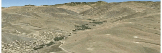
The development of a landslide-dammed lake following the Badakshan tragedy in northern Afghanistan posed a difficult challenge to the already devastated community. The initial landslide events killed more than 350 people, and blocked the main river - creating a lake that inundated buildings in the village. Increasing lake levels then threatened to collapse the dam and endanger communities downstream. A collaboration between members of the Landslide Research and Chair of Hydromechanics at TUM trialed a new methodology to quickly assess the potential flood hazard using freely available geodata and open-source software (QGIS, SAGA GIS, and OpenFoam). The groups aim to demonstrate how these tools can be employed for disaster response, and encourage communities to improve preparedness for such unforeseen events.
Management of the disaster response was shared between USGS, UNITAR/UNOSAT, NASA, FAO, WB, ICIMOD and SUPARCO, the US Army, the Government of Afghanistan, and other NGO's. Model results from TUM provided an insight into the 'worst case scenario', and gave local authorities confidence in works undertaken to drain the lake in a controlled manner.