Wildfire risk analysis for areas with Mediterranean climate
Within this project, we develop a framework for wildfire risk assessment, based on wildfire occurrence, fire behavior patterns and site vulnerability. Bayesian Networks are used to model influencing factors and their interdependencies. The distributions of the variables are learned with data managed in Geographic Information Systems and . Both environmental (weather, fuels, topography) and social (population, land use, street networks) factors influencing wildfire occurrence and spread are considered in the modeling. The models are implemented for Mediterranean areas, using high resolution temporal and spatial data (meteorological data, fire events, etc.). Maps are created to visualize risk in wildfire prone areas (e.g. Cyprus, South France).
Researchers
Publications
- Papakosta P., Straub D. (2013). A Bayesian network approach to assessing wildfire consequences. Proc. ICOSSAR 13, Columbia University, New York.
- Zwirglmaier K., Papakosta P., Straub D. (2013). Learning a Bayesian network model for predicting wildfire behavior. Proc. ICOSSAR 13, Columbia University, New York.
- Papakosta P., Straub D. (2013). Probabilistic prediction of fire occurrence in the Mediterranean based on weather and anthropogenic factors. International Journal of Wildland Fires. (submitted)
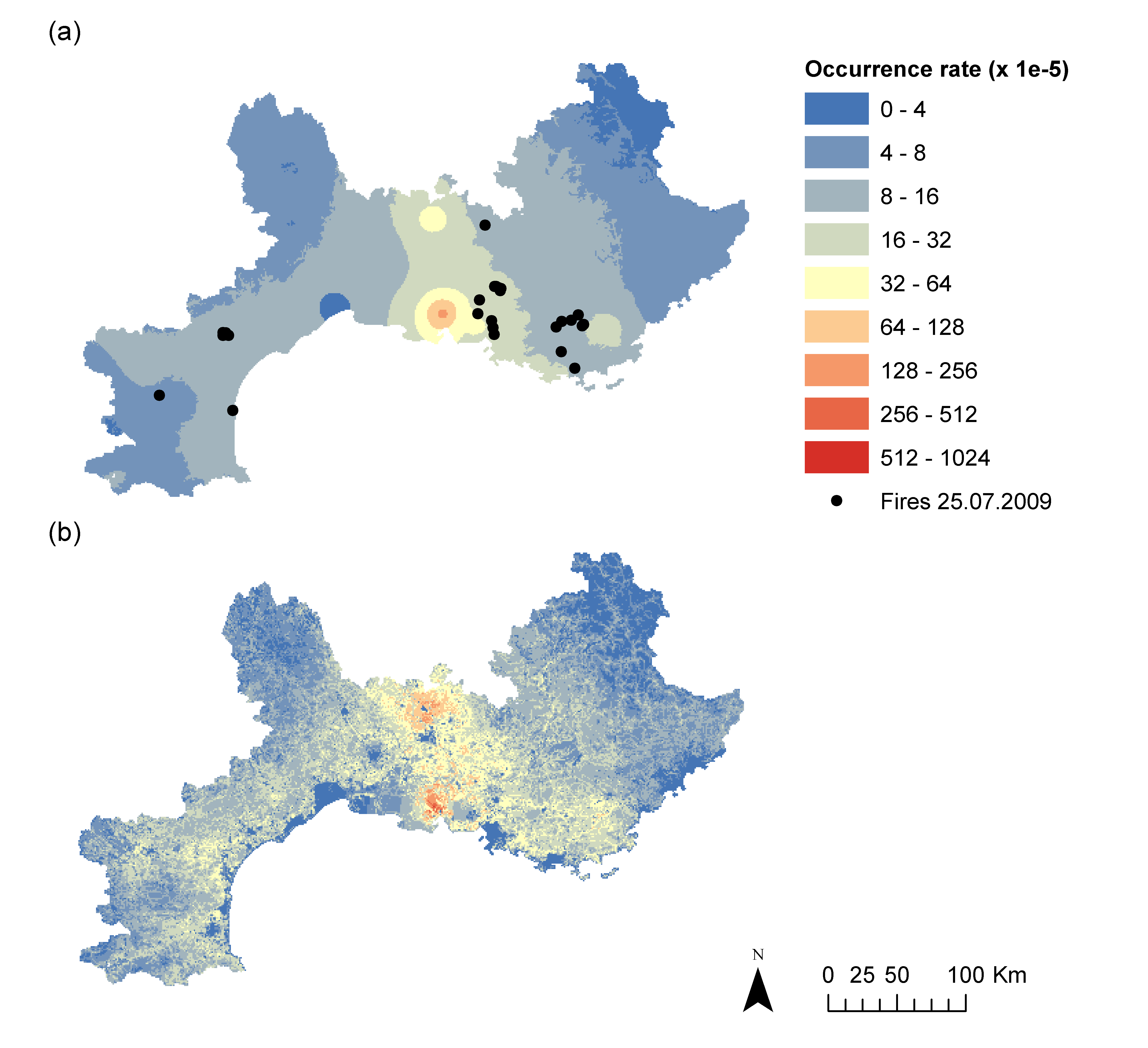
- Papakosta P., Öster J., Scherb A., Straub D. (2013). Fire occurrence prediction in the Mediterranean: Application to Southern France. Geophysical Research Abstracts, Vol. 15, EGU 2013-6336-1, EGU General Assembly 2013, Vienna
- Papakosta P., Botzler S., Krug K., Straub D. (2013). Measuring the consequences of wildfires in a Bayesian network with vulnerability and exposure indicators. Geophysical Research Abstracts, Vol. 15, EGU 2013-9959, EGU General Assembly 2013, Vienna
- Papakosta P., Klein F., König S., Peters S. and Straub D. (2012). Linking spatio-temporal data to the Fire Weather Index to estimate the probability of wildfire in the Mediterranean. Geophysical Research Abstracts, Vol. 14, EGU2012-12737, EGU General Assembly 2012, Vienna.
- Papakosta P., Straub D. (2011). Effect of Weather Conditions, Geography and Human Involvement on Wildfire Ignition: A Bayesian Network Model. Proc. ICASP 2011, Zürich.
- Papakosta P., Neuefeind S.A., Schaefer S. and Straub D. (2011). A probabilistic model of the influence of weather, geography and humans on wildfire occurrences in the Mediterranean. Geophysical Research Abstracts, Vol. 13, EGU2011-12734, EGU General Assembly 2011, Vienna.
Student projects
- Scherb A. (2014)
Coupling of Bayesian Networks with GIS for wildfire risk assessment and mapping in the Mediterranean - Dessauer E. (2014)
Wildfire Risk Data Management Development of a Spatio-Temporal Information System - Ederle S.(2013)
Vorhersage der Flächengröße von Großflächenbränden im Mittelmeerraum mittels linearer Regression - Scherb A., Öster J. (2013) Study project
Spatial-temporal data processing with GIS for wildfire prediction in South France - Botzler S. (2013) Study project
Implementation of an indicator based assessment method of wildfire consequences - Zwirglmaier K. (2012) Master Thesis
A Bayesian network model for predicting wildfire behavior in Mediterranean regions - Krug K. (2012) Bachelor Thesis
Measuring site vulnerability to wildfires - Assessment method and indicators - Klein F. (2012) Master Thesis
Linking a Bayesian network to a GIS for a wildfire occurrence model in Mediterranean areas - König S. (2012) Study Project
Application of the Fire Weather Index on the Mediterranean Island of Cyprus - Neuefeind S. (2011) Bachelor Thesis
Die Auftretenswahrscheinlichkeit von Großflächenbränden im Mediterranen Raum in Abhängigkeit von natürlichen und anthropogenen Faktoren am Beispiel von Rhodos. - Schäfer S. (2011) Bachelor Thesis
Abschätzung des Einflusses von Wetterbedingungen auf das Auftreten von Waldbränden, unter der Verwendung des Canadian Forest Fire Weather Index System.