SEHAG
Sensitivity of high Alpine geosystems to climate change since 1850
Climate change is frequently confirmed by historical and current measurement data. Since the 1980s, the Alps have experienced a warming that is significantly higher than the increase in the average global temperature.
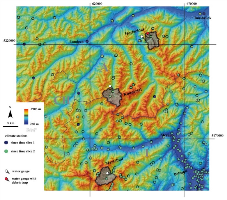
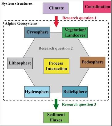
The research unit SEHAG investigates the impact of climate change on high Alpine geosystems since the end of the Little Ice Age (1850). For this purpose, scientists of various disciplines (climatology, geography, hydrology, botany and geodesy) from the Universities of Bremen, Eichstätt-Ingolstadt, Munich (TUM), Innsbruck and Vienna (TU) will collaborate closely. The investigations will be carried out in three Alpine valleys: Kaunertal and Horlachtal in Austria, and Martelltal in Italy.
The main activities of the project are:
- Reconstruction of the course of the weather from the end of the Little Ice Age by model calculations, which are constantly compared with the existing historical data series (e.g. on temperature and precipitation). The results are primarily used to provide possible explanations for observed changes; in concrete terms, the reconstructed weather data are used to understand the development of glaciers and the dynamics of runoff in rivers.
- Historical glacier conditions, the activity and intensity of processes such as mudslides and avalanches, as well as the development of the plant cover are reconstructed from historical photographs. Using modern methods, it is possible to determine the photographer's location and viewing direction and to edit the image itself in such a way that maps true to position and scale can be carried out.
- Scientists will carry out various measurements in the study areas during the duration of the project. Weather stations will record temperature, precipitation and wind; runoff in streams and rivers will be measured at gauging stations; digital models of slopes and valleys will be created from high-precision surveying with land-based or airborne laser instruments; drones will shoot aerial photographs documenting changes; staked out test areas will be visited again and again to record the composition of the plant cover. With all this data, we want to better understand how the Alpine landscape responds to changing conditions. Based on this understanding, we will try to predict changes in the near future (up to 2050) in a later phase of the project.
The Chair of Hydrology and River Basin Management of the Technical University of Munich (TUM) investigates within the SEHAG project changes occurred in the hydrosphere between 1850 and 2021 and how they are connected with the behavior of the different components of the high Alpine geosystem. Four objectives will be accomplished during the first three years of the project:
- Analyzing changes in the frequency and magnitude of modelled and observed hydrological extreme events (e.g., floods, droughts, extreme melting events driven by heatwaves, occurrence of rain on snow events and convective storms) in the three study areas eventually occurred in the timeframes 1850-1920, 1920-1980 and 1980-2021.
- Reducing uncertainty in hydrological model results in high elevation Alpine catchments constraining physically based models with highly resolved meteorological data, remote sensing data (e.g., glacier extension, snow cover), soil properties information (e.g., soil texture, permafrost and vegetation cover) and additional measurements such as streamflow water temperature and electrical conductivity. This objective will be achieved considering the data collected during the monitoring campaigns performed in the current research project (2019 - 2024) and therefore will be tested during both the first and the second phase of the project.
- Calibrating and validating a physically based hydrological model, describing with particular accuracy runoff generation caused by snow, glacier and permafrost melting processes. Particular emphasis will be given in elevation (and hence temperature) dependent processes. Moreover, the model will be developed also in the second phase (2022 - 2024) of the project to include temperature transport in the river network.
- Identifying the influences of climate, glacier and snow dynamics, geomorphologic changes as well as land cover changes to the hydrological response of Alpine catchments using calibrated models of different complexity (according to data availability) for the time frames 1850-1920, 1920-1980 and 1980-2021.
Funding Programme: Deutsche Forschungsgemeinschaft (DFG)
Project start: 01.01.2019
Project end: 31.12.2021
Project management: Prof. Dr.-Ing. Markus Disse, Prof. Dr. Gabriele Chiogna
Project assistance: Dr. Ye Tuo, M.Sc. Florentin Hofmeister, M.Sc. Daniel Bittner
Homepage: https://sehag.ku.de