GrüneGräben+
The current climate change, the historically determined drainage structure in the area and the fact that the district of Neustadt a.d.Aisch-Bad Windsheim is located in one of the regions with the lowest precipitation in Bavaria call for strategies and measures to improve the landscape water balance. The extreme drainage of the landscape has so far prevented the waterlogging of arable land. In the future, it will place a greater burden on water bodies with sediment and fine material input during heavy rainfall and contribute to a drop in groundwater levels. This is to be counteracted.
The GrüneGräben+ project is investigating how the existing ditches can be rededicated so that they continue to drain flood water, but at the same time return surface water to the ground via ditch damming, intermediate retention and infiltration, where it can be used as water available to plants or to support groundwater recharge through percolation.
Many ditches in the district and throughout Bavaria are potentially suitable for infiltrating water. A high degree of feasibility and effectiveness of the measure can therefore be expected if a high infiltration rate can be proven with the help of measurements. Calibrated simulations can then be used to transfer the effect of the measure when applied to a bigger area.
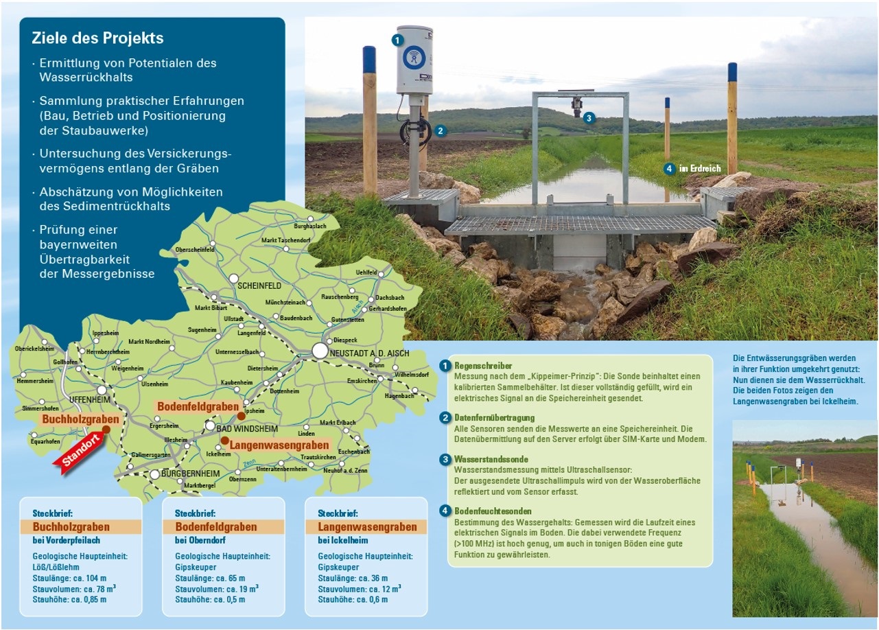
For these investigations, the Ansbach Water Management Administration already set up measuring points in the three study areas Buchholzgraben, Bodenfeldgraben and Langenwasengraben (see map). These areas are being investigated in detail.
The physically-based hydrological model HydroGeoSphere is being set up at field level for the individual ditches to be dammed. Here, the soil around and under the trenches is mapped at a very high spatial resolution in order to depict the relevant infiltration processes (infiltration volume and advancement of the moisture front), also taking into account shrinkage and swelling of the soils. HydroGeoSphere is created and calibrated on the plot scale (ditch) by using soil moisture data, water levels (reservoir volume) and meteorological data collected by the Ansbach Water Management Administration. In addition to Hydrogeosphere, various other calculation models are used to highlight detailed aspects or for control purposes.
In order to realistically record the local soil properties, soil samples are taken locally and analyzed for their hydrological properties. Furthermore, infiltration tests in the field are used to determine the saturated infiltration capacity and the preferential flow paths. Preferential flow paths are particularly important for infiltration at limited spatial scales. As the modeling of the trenches takes place on a very small spatial scale (resolution of decimeters), carefully planned test series are important in order to reproduce the infiltration realistically. These tests are carried out by the Technical University of Munich. The "plot modeling" is used to quantify the efficiency of the ditch damming for the adjacent arable land. Due to the detailed modeling of the soil moisture, statements can also be made about the current evapotranspiration and thus indirectly about the growth conditions of the arable plants. Depending on the research question, the microtopography could be important. A drone survey is carried out for this purpose. Based on this, the transfer or upscaling to catchment area level or landscape units can take place.
As part of the overarching project "Klimaresilienter Landkreis Neustadt a.d. Aisch - Bad Windsheim", workshops are being held with stakeholders to develop concrete proposals for water retention measures in the area.
The effectiveness of the selected measures for water retention in the area (protection against heavy rainfall and drought) depends, in addition to the catchment area characteristics, on the climatic boundary conditions. Since a further decrease in precipitation and at the same time a concentration of precipitation in (short-term) heavy rainfall events is to be expected, the consideration of climate scenarios is essential in order to obtain a meaningful estimate of the future effectiveness of measures.
Project funding: Wasserwirtschaftsamt Ansbach
Project start: 01.09.2023
Project end: 31.08.2026
Project partners: --
Project management: Prof. Dr. Markus Disse
Project assistance: Dr. Karl Broich
Weitere Informationen: https://www.wwa-an.bayern.de/grundwasser_boden/pilotprojekt_landschaftswasserhaushalt/index.htm